
North Dakota doesn’t shout for your attention.
It doesn’t need to.
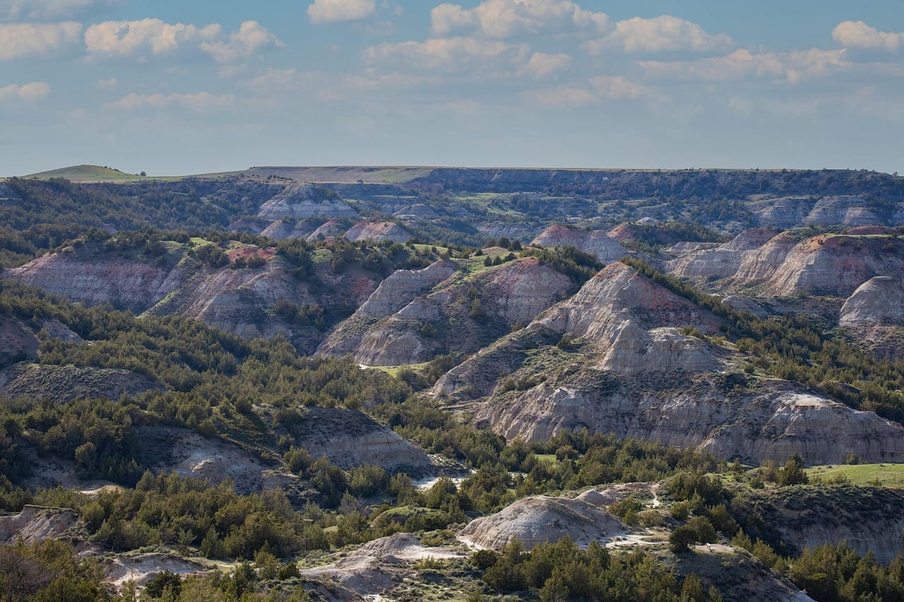
The state quietly waits until you turn off the interstate, drive over the next hill and suddenly discover a herd of bison wandering through the Badlands.
Or an enormous metal grasshopper standing beside a country highway.
Or an abandoned Cold War complex that looks suspiciously like the headquarters of a movie villain.
Or a peaceful prairie where the horizon seems to go on forever.
The best day trips in North Dakota are exactly the kind of adventures City Unknown loves—places where the road between destinations can be every bit as interesting as the destination itself.
You can hike through colorful Badlands.
Explore Theodore Roosevelt’s old ranch country.
Visit Indigenous village sites along the Missouri River.
Follow Lewis and Clark.
Drive past enormous roadside sculptures.
Explore Cold War history.
Visit an international garden sitting directly on the Canadian border.
Or simply pull over somewhere in the prairie and realize you haven’t heard another human being for ten minutes.
North Dakota rewards curious travelers.
So let’s go find the good stuff.
Jump to a North Dakota Region
Badlands & Theodore Roosevelt Country
Medora, Theodore Roosevelt National Park, Dickinson, Enchanted Highway and western Badlands.
Missouri River & Lake Sakakawea
Bismarck, Mandan, Knife River villages, Lake Sakakawea and Lewis & Clark history.
Turtle Mountains & North-Central
International Peace Garden, Lake Metigoshe, Bottineau and prairie backroads.
Red River Valley & Northeast
Fargo, Grand Forks, Pembina Gorge, Icelandic State Park and northeastern North Dakota.
James River & Sheyenne Valley
Jamestown, Valley City, Fort Ransom, grasslands and Cold War history.
Or jump directly to:
Scenic Drives | Hidden Gems | Cold War Sites | History | Family Trips | Budget Trips
Badlands & Theodore Roosevelt Country Day Trips
If you’re visiting North Dakota for the first time, start west.
The landscape changes dramatically as the prairie breaks apart into colorful buttes, gullies and rugged Badlands.
And right in the middle of it all sits one of America’s most underrated national parks.
Theodore Roosevelt National Park — South Unit
Location: Medora, North Dakota
Map: Open in Google Maps
Official Site: National Park Service
The South Unit is the most visited portion of Theodore Roosevelt National Park.
Expect Badlands scenery, prairie dog towns, hiking trails and excellent opportunities to see bison and other wildlife.
The scenic drive makes the park accessible even if hiking isn’t your thing.
But you’ll probably end up getting out of the car.
The Badlands have a way of doing that.
Best for: Wildlife, hiking, families, photography and first-time North Dakota visitors.
City Unknown Tip: Bison are not oversized cows interested in meeting you.
Give them plenty of room.
Painted Canyon
Location: East of Medora
Map: Open in Google Maps
The Painted Canyon overlooks provide one of the easiest introductions to North Dakota’s Badlands.
It’s right off Interstate 94.
Which makes this one of those rare highway rest stops where you may accidentally spend an hour.
Medora
Location: Medora, North Dakota
Map: Open in Google Maps
Planning: Visit Medora
This tiny western town serves as the gateway to Theodore Roosevelt National Park.
Historic buildings, shops, restaurants and seasonal entertainment make Medora considerably livelier than its population would suggest.
Best for: Families, history and western atmosphere.
Chateau de Morès State Historic Site
Location: Medora
Map: Open in Google Maps
The home of French aristocrat and entrepreneur Antoine de Vallombrosa, Marquis de Morès, provides a fascinating glimpse into Medora’s cattle-boom era.
Pair it with Theodore Roosevelt National Park and downtown Medora.
Theodore Roosevelt National Park — North Unit
Location: South of Watford City
Map: Open in Google Maps
Official Site: National Park Service
The North Unit is quieter and feels considerably more remote than the South Unit.
A scenic road follows the Little Missouri River through rugged Badlands terrain.
Best for: Wildlife, solitude, photography and hikers.
Don’t assume you can quickly bounce between the North and South Units.
They’re separate destinations.
Little Missouri State Park
Location: Near Killdeer
Map: Open in Google Maps
Deep Badlands terrain makes this one of North Dakota’s wilder state parks.
Much of the park is best suited to hiking and horseback riding.
Best for: Experienced outdoor travelers and solitude.
Dickinson
Location: Dickinson, North Dakota
Map: Open in Google Maps
Dickinson makes a useful western North Dakota base and an easy stop between Bismarck and Medora.
Dickinson Museum Center
Location: Dickinson
Map: Open in Google Maps
Dinosaurs, regional history and historic buildings make this an excellent family stop.
Especially when western North Dakota weather decides your hiking plans were merely suggestions.
Enchanted Highway
Location: Gladstone to Regent
Map: Open in Google Maps
This is peak City Unknown.
Giant metal sculptures rise from the prairie along a rural highway between Gladstone and Regent.
You’ll encounter enormous geese.
Grasshoppers.
Deer.
A giant tin family.
And other pieces created by artist Gary Greff.
Do you need a practical reason to drive miles across North Dakota to see a giant metal grasshopper?
Absolutely not.
That’s the reason.
Best for: Road trips, photography, families and roadside-attraction collectors.
White Butte
Location: Near Amidon
Map: Open in Google Maps
White Butte is North Dakota’s highest natural point.
The hike crosses private property, so respect current access instructions, signage and any requested contribution or rules.
Best for: State high-point collectors.
Fort Union Trading Post National Historic Site
Location: Near Williston
Map: Open in Google Maps
Official Site: National Park Service
This reconstructed trading post interprets the Upper Missouri fur trade and the complex relationships among Native nations and Euro-American traders.
Its location near the Montana border makes it a long haul from many North Dakota cities but an excellent western road-trip destination.
Missouri-Yellowstone Confluence
Location: Near Williston
Map: Open in Google Maps
Two of the West’s great rivers meet near the North Dakota-Montana border.
Combine it with Fort Union for an excellent history-and-landscape day.
Missouri River & Lake Sakakawea Day Trips
Central North Dakota follows one of America’s great rivers.
This region brings together Indigenous history, Lewis and Clark, the state capital and an enormous reservoir stretching across western North Dakota.
Bismarck
Location: Bismarck, North Dakota
Map: Open in Google Maps
North Dakota’s capital makes an excellent starting point for exploring the Missouri River corridor.
Museums, historic sites and riverfront trails can easily fill a day.
North Dakota Heritage Center & State Museum
Location: Bismarck
Map: Open in Google Maps
Dinosaurs.
Geology.
Indigenous history.
State history.
North Dakota manages to fit several million years into one building.
Best for: Families, history and rainy days.
Fort Abraham Lincoln State Park
Location: Mandan
Map: Open in Google Maps
This important historic site interprets multiple layers of North Dakota history.
Reconstructed earthlodges represent the On-A-Slant Mandan village, while reconstructed military buildings interpret Fort Abraham Lincoln and the 7th Cavalry.
George Armstrong Custer lived here before the 1876 Battle of the Little Bighorn.
But don’t reduce the site to Custer.
The Mandan story here reaches much deeper.
Best for: History and families.
Double Ditch Indian Village State Historic Site
Location: North of Bismarck
Map: Open in Google Maps
Earthworks reveal the footprint of a large Mandan village overlooking the Missouri River.
It’s a quieter archaeological site that deserves considerably more attention.
Knife River Indian Villages National Historic Site
Location: Stanton, North Dakota
Map: Open in Google Maps
Official Site: National Park Service
This National Park Service site preserves village locations associated with Northern Plains Indigenous communities, particularly Hidatsa and Mandan peoples.
Walk trails to village sites and explore the visitor center and reconstructed earthlodge.
The area was also home to Sakakawea before she joined the Lewis and Clark Expedition.
Best for: Indigenous history, archaeology and families.
City Unknown Tip: Treat the earthlodge villages as living cultural history rather than relics of a vanished people. Mandan, Hidatsa and Arikara communities continue today.
Lewis & Clark Interpretive Center
Location: Washburn
Map: Open in Google Maps
Exhibits explore the Corps of Discovery and the expedition’s winter near the Mandan and Hidatsa villages.
Pair it with nearby Fort Mandan.
Fort Mandan
Location: Washburn area
Map: Open in Google Maps
A reconstruction interprets the fort where the Lewis and Clark Expedition spent the winter of 1804–1805.
Lake Sakakawea
Location: Central and western North Dakota
Map: Open in Google Maps
One of America’s largest reservoirs stretches across an enormous portion of western North Dakota.
Boating, fishing, camping and shoreline recreation make it a major summer destination.
Lake Sakakawea State Park
Location: Pick City
Map: Open in Google Maps
Trails and shoreline recreation provide excellent access to the lake near Garrison Dam.
The park is also the western terminus of the North Country National Scenic Trail.
Garrison Dam
Location: Riverdale
Map: Open in Google Maps
The enormous dam created Lake Sakakawea.
The engineering achievement is impressive.
Its history is also complicated: construction of Garrison Dam displaced communities of the Three Affiliated Tribes and inundated extensive portions of their Missouri River homelands.
Understanding both stories makes this a much more meaningful stop.
Audubon National Wildlife Refuge
Location: Near Coleharbor
Map: Open in Google Maps
Wetlands and prairie surrounding Lake Audubon attract waterfowl and other wildlife.
Best for: Birding, photography and quiet nature trips.
Turtle Mountains & North-Central Day Trips
North Dakota isn’t completely flat.
The Turtle Mountains would like a word with whoever started that rumor.
Forests, lakes and rolling hills create a surprisingly different landscape near the Canadian border.
International Peace Garden
Location: Dunseith, North Dakota / Manitoba border
Map: Open in Google Maps
Official Site: International Peace Garden
The International Peace Garden celebrates friendship between the United States and Canada.
Formal gardens, trails, memorials and the conservatory make this an unusual international destination.
Best for: Gardens, families and international-border novelty.
Important: Because the garden sits on the international boundary, review current identification and border-crossing requirements before going.
Don’t arrive at an international border armed only with optimism and a library card.
Lake Metigoshe State Park
Location: Bottineau area
Map: Open in Google Maps
Woodlands and lakes make this park look surprisingly unlike the stereotypical image of North Dakota.
Summer brings paddling and hiking.
Winter transforms the area into a snowy recreation destination.
Bottineau
Location: Bottineau, North Dakota
Map: Open in Google Maps
Bottineau serves as a gateway to the Turtle Mountains and International Peace Garden.
Mystical Horizons
Location: Near Bottineau
Map: Open in Google Maps
Stone structures align with celestial events and overlook the surrounding prairie.
It has earned the nickname “Stonehenge of the Prairie.”
A considerably less crowded Stonehenge, admittedly.
Scandinavian Heritage Park
Location: Minot
Map: Open in Google Maps
Buildings, statues and monuments celebrate the Scandinavian cultures that influenced North Dakota.
Fort Stevenson State Park
Location: Garrison
Map: Open in Google Maps
Lake Sakakawea recreation and regional history combine at this central North Dakota park.
Red River Valley & Northeast North Dakota Day Trips
Eastern North Dakota trades Badlands for fertile prairie, river valleys and some of the state’s most attractive wooded landscapes.
Fargo
Location: Fargo, North Dakota
Map: Open in Google Maps
North Dakota’s largest city has restaurants, museums, public art and a downtown that deserves more attention than the movie reference everyone makes.
Yes.
There is a wood chipper display.
Now that we’ve gotten that out of the way, keep exploring.
Fargo Air Museum
Location: Fargo
Map: Open in Google Maps
Historic aircraft and aviation exhibits make this an easy family stop.
Bonanzaville
Location: West Fargo
Map: Open in Google Maps
Historic buildings, vehicles and exhibits form a sprawling regional-history museum.
Grand Forks
Location: Grand Forks, North Dakota
Map: Open in Google Maps
Downtown, university attractions and the Greenway along the Red River make Grand Forks an easy eastern North Dakota getaway.
Turtle River State Park
Location: Near Arvilla
Map: Open in Google Maps
Wooded trails follow the Turtle River west of Grand Forks.
Fall colors make this particularly attractive in autumn.
Icelandic State Park
Location: Cavalier
Map: Open in Google Maps
Trails, Lake Renwick and regional history make this one of northeastern North Dakota’s strongest state-park trips.
Pembina Gorge State Park
Location: Walhalla area
Map: Open in Google Maps
Steep wooded valleys and the Pembina River create one of North Dakota’s most unexpected landscapes.
Hiking, mountain biking, horseback riding, paddling when conditions allow and off-highway vehicle trails provide plenty of ways to explore.
Best for: Fall foliage, hiking and outdoor adventure.
Walhalla
Location: Walhalla, North Dakota
Map: Open in Google Maps
One of North Dakota’s oldest communities makes an excellent companion to a Pembina Gorge trip.
James River & Sheyenne Valley Day Trips
Central-eastern North Dakota mixes prairie, river valleys, pioneer history and some excellent Cold War relics.
Jamestown
Location: Jamestown, North Dakota
Map: Open in Google Maps
Jamestown’s most famous resident weighs roughly 60 tons.
Fortunately, he doesn’t move much.
World’s Largest Buffalo Monument
Location: Jamestown
Map: Open in Google Maps
The enormous concrete bison known as Dakota Thunder has overlooked Jamestown since 1959.
Roadside America at its finest.
National Buffalo Museum
Location: Jamestown
Map: Open in Google Maps
The museum explores bison history, ecology and their relationship with people of the Great Plains.
A live bison herd can also be seen nearby when the animals choose to cooperate.
Valley City
Location: Valley City, North Dakota
Map: Open in Google Maps
Known as the City of Bridges, Valley City sits along the Sheyenne River.
Hi-Line Bridge
Location: Valley City
Map: Open in Google Maps
This enormous railroad bridge towers over the Sheyenne River valley.
It’s an impressive engineering landmark and an easy photography stop.
Fort Ransom State Park
Location: Fort Ransom
Map: Open in Google Maps
Rolling hills and wooded river valleys provide hiking, paddling and seasonal recreation.
This is another destination that challenges the “North Dakota is completely flat” stereotype.
Sheyenne National Grassland
Location: Southeastern North Dakota
Map: Open in Google Maps
Native prairie and sandhills preserve an unusual ecosystem southeast of Fargo.
Best for: Hiking, wildlife and solitude.
North Dakota Cold War Day Trips
North Dakota’s wide-open geography made it strategically important during the Cold War.
Today several sites preserve that history.
And some look like they were designed specifically for a James Bond movie.
Ronald Reagan Minuteman Missile State Historic Site
Location: Near Cooperstown
Map: Open in Google Maps
The preserved Oscar-Zero Missile Alert Facility and November-33 Launch Facility interpret North Dakota’s role in America’s nuclear deterrent.
Check current tour schedules before visiting.
Stanley R. Mickelsen Safeguard Complex
Location: Near Nekoma
Map: Open in Google Maps
The enormous pyramid-shaped radar structure is one of North Dakota’s strangest landmarks.
Often called the “Pyramid of North Dakota,” it was part of an anti-ballistic missile defense system.
Important: Do not assume you can enter the property.
Ownership and access conditions can change. View only from legal public areas unless an authorized tour or event specifically allows access.
Trespassing is not urban exploration.
It’s trespassing.
Hidden Gems Worth the North Dakota Detour
Enchanted Highway
Giant metal sculptures on a rural road.
Enough said.
Mystical Horizons
North Dakota’s prairie astronomy monument.
Fairview Lift Bridge & Cartwright Tunnel
Location: Near Cartwright
Map: Open in Google Maps
An old railroad lift bridge and tunnel create one of western North Dakota’s more unusual historic stops.
Check current legal access before exploring.
Double Ditch Indian Village
A major Mandan village site overlooking the Missouri River.
White Butte
Stand on the highest natural point in North Dakota.
Pembina Gorge
Forested valleys in a state most visitors expect to be endless prairie.
Lake Metigoshe
Lakes and forests near the Canadian border.
Fort Ransom
Rolling hills and wooded valleys.
Medicine Wheel Park
Location: Valley City
Map: Open in Google Maps
An outdoor educational site combines astronomy, Native-inspired interpretive elements and prairie landscape.
Best Scenic Drives in North Dakota
Theodore Roosevelt National Park Scenic Roads
Badlands, bison and prairie dog towns.
Check current park road conditions before visiting.
Enchanted Highway
One of America’s quirkiest roadside-art drives.
Killdeer Mountain Four Bears Scenic Byway
Western landscapes and Missouri River country make this an excellent alternative to Interstate 94.
Sheyenne River Valley National Scenic Byway
Follow the river valley through southeastern North Dakota.
Rendezvous Region Scenic Backroads
Explore northeastern North Dakota around Walhalla and Pembina Gorge.
Sakakawea Country
Build a loop around portions of Lake Sakakawea and the Missouri River.
North Dakota History Day Trips
History here goes far beyond pioneer cabins.
Explore:
Knife River Indian Villages
Double Ditch Indian Village
Fort Abraham Lincoln
Fort Union Trading Post
Fort Mandan
Lewis & Clark Interpretive Center
Chateau de Morès
Ronald Reagan Minuteman Missile Site
Bonanzaville
North Dakota Heritage Center
The state’s story includes thousands of years of Indigenous history, the fur trade, westward expansion, agriculture, railroads and the Cold War.
North Dakota Indigenous Heritage
Some of the state’s most important historical destinations are associated with the Indigenous nations of the Northern Plains.
Places to explore include:
Knife River Indian Villages National Historic Site
Double Ditch Indian Village State Historic Site
On-A-Slant Village at Fort Abraham Lincoln
North Dakota Heritage Center
When visiting, remember these are not stories about peoples who simply disappeared into history.
The Mandan, Hidatsa, Arikara, Lakota, Dakota and other Native communities remain part of North Dakota today.
Best North Dakota Day Trips for Families
Try:
Theodore Roosevelt National Park
Painted Canyon
Enchanted Highway
National Buffalo Museum
North Dakota Heritage Center
Fort Abraham Lincoln
International Peace Garden
Lake Metigoshe
Bonanzaville
Dickinson Museum Center
Icelandic State Park
Pembina Gorge
North Dakota is particularly good for families who enjoy road trips because many attractions involve the journey itself.
Just pack snacks.
Lots of snacks.
There can be considerable prairie between snack opportunities.
Romantic North Dakota Day Trips
For couples, try:
Medora
Theodore Roosevelt National Park at sunset
International Peace Garden
Lake Metigoshe
Pembina Gorge
Lake Sakakawea
Fort Ransom
Sheyenne River Valley
Sunset over the Badlands is especially difficult to beat.
Budget-Friendly North Dakota Day Trips
Some of North Dakota’s best adventures don’t require an expensive ticket.
Build trips around:
Scenic drives
Wildlife refuges
Historic downtowns
Prairie trails
Roadside art
State historic sites
Public museums
National grasslands
Lake overlooks
Hiking trails
Riverfront parks
Wildlife watching
Fees and admission policies change.
Check the current official site instead of relying on an old article that promises “$5 admission.”
North Dakota has changed since somebody wrote that.
So has five dollars.
Best North Dakota Wildlife Day Trips
North Dakota’s wildlife may include:
Bison
Elk
Mule deer
White-tailed deer
Bighorn sheep
Pronghorn
Prairie dogs
Coyotes
Bald eagles
Waterfowl
Wildlife is wild.
Sightings aren’t guaranteed.
Keep a safe distance, particularly from bison.
A bison can weigh close to a ton and run considerably faster than your vacation plans.
Best North Dakota Fall Day Trips
Fall is short.
Which makes it even better.
Try:
Pembina Gorge
Turtle River State Park
Icelandic State Park
Lake Metigoshe
Fort Ransom
Theodore Roosevelt National Park
Killdeer Mountains
Colors and timing depend on weather.
Northeastern North Dakota’s wooded valleys are particularly beautiful.
Best North Dakota Summer Day Trips
Summer opens the widest range of adventures.
Try:
Theodore Roosevelt National Park
Medora
Lake Sakakawea
International Peace Garden
Lake Metigoshe
Pembina Gorge
Enchanted Highway
Fort Union
Knife River Indian Villages
Fort Ransom
Thunderstorms and heat can still change plans quickly.
Carry water.
Best North Dakota Winter Day Trips
North Dakota does winter properly.
Try:
Lake Metigoshe
Bottineau area
Turtle River State Park
Fargo museums
Bismarck museums
Fort Ransom
Cross-country skiing
Snowshoeing
But treat winter driving seriously.
Distances are long.
Wind can reduce visibility rapidly.
And “it’s only 40 miles away” sounds considerably different during a North Dakota blizzard.
North Dakota Road-Trip Planning
Good combinations include:
Medora → Theodore Roosevelt South Unit
Painted Canyon → Medora
Dickinson → Enchanted Highway
Williston → Fort Union → Missouri-Yellowstone Confluence
Bismarck → Fort Abraham Lincoln
Bismarck → Double Ditch
Washburn → Fort Mandan → Knife River Indian Villages
Garrison Dam → Lake Sakakawea State Park
Bottineau → Lake Metigoshe → International Peace Garden
Grand Forks → Turtle River State Park
Walhalla → Pembina Gorge
Fargo → Bonanzaville
Jamestown → National Buffalo Museum
Valley City → Fort Ransom
Don’t try:
Fargo → Medora → Fargo
Could you?
Sure.
You could also spend most of your North Dakota vacation staring through a windshield.
Make Medora an overnight trip from eastern North Dakota.
One North Dakota Road-Trip Rule Worth Remembering
Fill the gas tank.
Then fill it again when you have the chance.
North Dakota distances can be deceptive.
Services become sparse in rural areas.
Cell coverage may disappear.
Winter changes everything.
And some of the best places are exactly where convenience stores are not.
Carry:
Water.
Snacks.
A paper or downloaded map.
Weather-appropriate clothing.
And enough fuel that the low-gas warning doesn’t become the most memorable attraction of your trip.
More North Dakota Adventures from City Unknown
Continue exploring the Peace Garden State:
North Dakota Hidden Gems — Discover forgotten towns, unusual landscapes and strange roadside attractions.
North Dakota Badlands Road Trip — Explore Theodore Roosevelt country beyond the national park.
North Dakota Small Towns — Find prairie communities worth leaving the interstate for.
North Dakota Scenic Drives — Follow Badlands roads, river valleys and prairie byways.
North Dakota Cold War Road Trip — Explore missile sites and remnants of America’s nuclear-defense era.
North Dakota Indigenous Heritage Road Trip — Explore village sites and cultural history along the Missouri River.
North Dakota Weird & Unusual Places — Giant sculptures, mysterious pyramids and wonderfully strange roadside stops.
North Dakota Ghost Town Road Trip — Explore fading prairie communities and abandoned places.
North Dakota Wildlife Road Trip — Search for bison, elk, pronghorn and prairie dogs.
North Dakota Fall Road Trip — Chase autumn through Pembina Gorge and the Turtle Mountains.
Find Your Next North Dakota Adventure
Visit Theodore Roosevelt National Park.
See Medora.
Drive the Enchanted Highway.
Those are easy choices.
Then keep going.
Drive north toward the Canadian border.
Follow the Missouri River.
Visit a Mandan village site.
Stand beneath a Cold War radar pyramid.
Walk through prairie grass taller than expected.
Stop in the tiny town you hadn’t planned to visit.
Watch bison cross the road.
Pull over for a sunset.
North Dakota isn’t a state that hands you an attraction every five miles.
That’s part of its charm.
You have to look.
And once you start looking, there’s considerably more here than most travelers expect.
City Unknown Tip
North Dakota’s greatest attraction may be the empty space between its attractions.
Don’t rush through it.
Take the two-lane road.
Stop at the strange roadside sculpture.
Explore the tiny museum.
Watch the prairie disappear into the horizon.
And when somebody tells you there’s “nothing in North Dakota,” smile.
They clearly didn’t take the right road.